
map
June 30th, 2007 | Uncategorized
Hey, look. The Clustrmap is working again. Unfortunately, it seems to be starting over from scratch, and not resuming at the point where it shut down many months ago. Still, there’s rather an impressive sprinkling of dots. It’s funny to look at it because I was just examining this cool old schoolroom map of the world that I bought at Liza’s gallery, Pine Street Art Works, the other day.
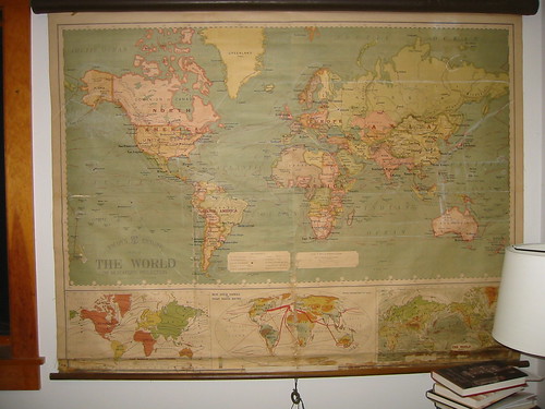
I’m trying to figure out when it was printed by the countries and cities on it. All I can tell so far is that it’s post-Russian revolution and pre-World War II.
114 Responses to “map”
Ooh, I love old maps. One thing that catches my eye is the use of Constantinople instead of Istanbul, and according to my exhaustive research (i.e. Wikipedia) the name was officially changed in 1930 (although it had been called Istanbul long before). Of course, it could be obstinacy on the part of the mapmakers so I suppose that doesn’t really tell you much.
According to Wikipedia “With the Turkish Postal Service Law of March 28, 1930, the Turkish authorities officially requested foreigners to cease referring to the city with their traditional non-Turkish names (such as Constantinople, Tsarigrad, etc.) and to adopt Istanbul as the sole name also in their own languages.”
Maybe this places the map pre 1930’s because Istanbul is called Constantinople – as far as I can see on the image.
Perhaps there is a printing date in some obscure spot on the map itself, other than the legend, or perhaps there are records from the mapmaking company, traced by some obscure information in the legend? It’s not as much fun as sussing it out by place names, but might be just as interesting in the long run.
ah, the clustr map doesn’t separate out Nunavut.
Hard to tell at this distance, but the Istrian penninsula doesn’t seem to be part of Italy at that point. By memory, that was the case before WWI (and after WWII). The Istrian penninsula is south of Trieste.
There used to be a country called Galicia in the south of Poland, before WWI. (Not to be mistaken for the area in Spain called Galicia, too.)
There’s got to be a date on there somewhere.
I can’t see what it says from here, but the capital of Norway changed its name from Kristiania to Oslo in 1924 – hope that helps somewhat.
I’ve used this list to date a couple of globes in moments of extreme desperation: http://www.maps-globes.com/cram/faq/howold.pdf Can’t tell if Persia has yet to become Iran in yours. It’s odd how they never seem to be dated, as if each time the cartographers believed they’d finally gotten it right once and for all.
Wait a minute. I spy Alaska. There’s a pbs special about Alaska coming up (but I won’t be watching it :-)). Oh, yeah, there’s also something called “the web.” Might be a place to learn more. LOL.
Looks like someone has drawn chalk marks in swirls and stuff on the map.
Why did Constantinople get the works? That’s nobody’s business but the Turks’.
Does in include Tannu-Tuva? And what is going on in that pink area of Central Asia where the “Stans” are located?
I’m working on a map right now: the north Olympic Peninsula in the style of Christopher Saxton, well-known English cartographer of the 16th century. Steel-tip pen and india ink on parchment-paper; you can’t make something look 16th century with a felt-tip pen. Saxton’s text is all in Latin, but I make no promises about my Latin translations of modern phrases. Can anyone one this highly intellectual blog tell me if “Opera Sasquatchi Volatilis” is a reasonable translation of “Flying Sasquatch Productions”? That’s the “trademark” I use for everything I make.
There is really no need for me to go to all this trouble. I’m making it for use on stage in the Seattle Gilbert and Sullivan Society’s production of “Princess Ida.” Opening night is the 13th, and I need to get it done at least a week before that. Only the cast will appreciate it; the audience won’t see anything.
They will, however, see an enormous globe (papier mache over a beach ball), which might be painted to look like the oldest known surviving globe, based on the famous Waldseemuller world map of 1502. Anyway, I recommended it, and lent them a book which has pictures of both globe and map.
If you’re in the area, check it out. I’ll be at the back of the house, running a video camera hooked up to a monitor in the pit.
Jana C.H.
Seattle
Saith Simone Andrus: Cartographers make the world go ’round.
Bridges– Why do cartographers not date maps and globes? Because in a few years people will stop buying your map and buy something newer. It’s pure marketing. If you produce something like a local street atlas for which you crank out a new edition each year, you make the date prominent so people will replace their old editions frequently. But a globe or a wall map is a big investment that the buyer will probably not be replacing any time soon. So you don’t want to make a point of its shelf life.
That said, I always put dates on my maps, and I like to see them on other peoples’ maps. I own an undated globe from the Thirties that includes Tannu-Tuva, Manchukuo, Chosen, Eritrea, amd the British Empire all in pink.
Jana C.H.
Seattle
Saith JcH: Cartographers do it to scale.
Oh. Using this web thing I was able to learn the Russian Revolution happened in 1917 or so. Now, why did I think it was before the turn of the century? That makes much less of a window of time than I thought.
The Istrian penninsula (I mentioned it earlier) must be part of Italy on the map, then (if the map is correct). It just looks a little darker than Italy for some reason.
This has been an interesting detective-work discussion.
I can’t see clearly whether there is a unified Czechoslovakia. If so, it is post 1918.
Jana C.H. – Your cartographic taglines made me smile. I make maps for a living, but I’ve never braved one with a steel-point pen! Wish I could see your production (also the play!).
The clustmap has such a big hole across all of Africa – just ten visitors in Johannesburg during the month, for the whole continent. Does this reflect the lack of net access, or a prevailing homophobia? Or maybe the clustrmap doesnt pick up all visits? Ditto central Asia but somehow I’d expect that, with fewer people. Obviously language is an issue – but with the translation into French, is your publisher missing an opportunity here?
Fun Home doesn’t list this blog, do the DTWOF books?
I totally bet that all of those visits from Moscow are me…and I definitely know the single visitor from Armenia.
Does anyone know if the map counts by individual IP addresses, or whether it’s simply the number of times the page is viewed?
I’ve never clicked on that Clustrmap before – that thing is cool! I’d love to know who the folks are who live in more secluded areas, like Faeroe Island, or even the middle of Australia or (what looks like) the Northwest Territories.
Alison, what I like about your map is that it looks accurate with regard to land mass size. I’d love to find one like that; so many maps have Texas almost the same size as Alaska.
Oh, Russia, such a big country, why so few readers?
Can you publish a higher-resolution version of the map? I’d like to zoom in better.
Whenever I hear Constantinople and Istanbul I think of There Might Be Giants…remember Triangle Man? Wow, that was way off topic 🙂
I’m a huge TMBG fan. I had to almost physically restrain myself from making a reference.
I can’t tell for sure but it looks like Burma is colored the same as (British) India. It looks like the pink extends from India across what is now Bangladesh and Burma (Myanmar) to the boarder of Thailand (Siam). That would mean it is pre-1937. (Technically Burma became its own colony under the British in 1935 but it didn’t take effect until 1937.)
How fun!
Well, Newfoundland and Labrador were a separate entity from Canada until 1949, so this map seems to be from after that year. Also, the huge purple blob that is French West Africa ceased to exist in 1958, so it seems that this map must be from between 1949 and 1958.
But Burma is shown as part of British India, and it was separated in 1937.
Then again, the capital of Norway is labelled as Christiania, whose name someone else pointed out was changed to Oslo in 1924. So, I dunno. It’s a fun mystery!
(all of this is from Wikipedia)
Ooo! More clues…. St. Petersburg is labelled as Petrograd, which was the name of that city from 1914 to 1924.
And the borders of Finland include parts that were ceded to the Soviet Union in 1940, implying the map must be pre-1940.
Confusing!
Ginjoint this map is a Mercator projection which still greatly distorts actual area in favor of Europe. The kind of map you seek is called a Peters projection.
Also, Estonia, Latvia and Lithuania are shown as independent, which would place us between 1920 and 1939.
Fun! Here are my two Canadian cents: the “Dominion of Canada” lasted from 1867 to 1931. So… would that place us between 1920 and 1931?
If all the clues above are correct, it’s narrowed down to between 1920 and 1924.
Cool…what a collective we have here. Fascinating and frightening at the same time. You are a source for all things.
Pam I,
The paperback edition of Fun Home does list the url for this blog.
Suzanon,
My Pop-pop used to take me to a little newspaper/magazine shop that was owned and run by a man he called “The Galicianer”. Pop-pop would get his newspapers and he would let me pick out a candy bar. I was young, maybe four or so, when one time Pop-pop forgot to offer and I picked up a candy bar anyway. I thought that’s what we did at the Galicianer’s store. When we got home Pop-pop noticed the candy and gave me a brief lecture on stealing and made me go back to the store with some change to pay. I was mortified, perhaps why that memory remained.
Now we’re plain old ordinary Eastern European Jews…I don’t know any Galicianers. When my Lithuanian Prof. in undergrad learned my family was from Lithuania he asked me what town. I asked my Great Aunt. My professor broke up laughing when I told him the name of the town. He explained that I had said,”I was born in Kovna”. Just what my great-grandparents had told their children.
oh, Kaunas, not Kovna.
Aunt Soozie, on census records and in casual use from 1900 to 1920, Galicia was often used as a synonym for Poland. Not technically accurate, but in Jewish culture you should be aware of it. And Auschwitz (O?wi?cim) is in the former Duchy of Galicia.
thanks filosopher
like I said…a source for all things…
Alison’s web guru,
Speaking of Pine Street Art Works…when I click on the orange box that says, buy Alison’s art from PSAW, on the top right it shows me the little movie but then I’m still here…should it take me to the Pine Street website? I’m on an iMac with Firefox. The link underneath, in the “links” area does get me there.
Aunt Soozie, you provided me with the final clue to resolve a the PSAW ad. Thanks. Should work fine now on internal blog pages (always worked fine on the home page).
Also, something that might be useful in the map mystery: http://en.wikipedia.org/wiki/Treaty_of_Trianon
There are lots of equal-area projections; the Peters projection is only one, and it is a particularly poor one. I would suggest instead Mollweide or Goode’s Homolosine.
The Mercator projection is a different type, which is intended for use in navigation. It was not designed to make people think polar countries are larger than tropical countries, though it has that effect. It was designed to show lines of equal bearing as straight lines. That’s all.
Why the Mercator keeps getting hung up in classrooms that have nothing to do with navigation is a good question. Maybe it’s because it’s rectangular, which good equal-area projections often are not. If we’re going to buy a great big wall map, we want to make sure we get 100% map, without wasted white area around the edges.
Thank you to Arthur Robinson and my 30-year-old copy of “Elements of Cartography”.
Jana C.H.
Seattle
Saith Mark Monmonier: Not only is it easy to lie with maps, it’s essential.
Sooz and J-lo. The “buy alison’s art at PSAW” has never worked. I get the *movie* but no link. But if you click on the link to pine street art works in the “links” section you can get to the website. Oh, and I still have framed originals from Fun Home and DTWOF for sale, if anybody’s interested.
Meanwhile, you readers (oh my god, I almost said ‘you guys”) are great at figuring out the map. Like the History Detectives!! I had the map figured at the 1920’s as well, based on cities and countries. It was great fun having it on the gallery wall because many people would get absorbed in trying to figure out when it was made. It’s a gorgeous piece of work. I bought it at an auction: waited almost a whole day for it to come up. But I’m awfully glad that Alison decided to buy it and share it with y’all.
If I have problems in the future figuring out dates for things, can I come to you?
Oh, G-Lo (sorry about calling you J-lo, but I always think of you as Gahlord) I see what you mean about the link working from the home page. I never got that there was a difference before. Aha!
Thanks, filosopher and Jana!
During the Cold War, I remember being told that the Soviet Union particularly liked the Mercator projection because it made them look SO MUCH BIGGER than the little puny U.S. I did grow up thinking Greenland was nearly as large as all of North America, however.
A new word, courtesy of Jana! Homosoline (projection): A map of the earth’s surface laid out on the basis of sinusoidal curves, with the interruptions over ocean areas distorted so that the continents appear with minimal distortion. Which of course led to sinusoidal: having a succession of waves or curves.
Sacrificing the ocean’s integrity so the land looks right. Sounds familiar. And some women’s bodies have a succession of curves. The Goode ones, I presume.
Mollweide: What a female gangster smokes to relax. (?)
Diving into this rex of map linguistics, I discover other projections:
The Bonne projection
The Bonne, Lambert azimuthal equal-area projection
The Albers equal-area projection
The Boggs eumorphic projection
The Gall-Peters projection (offspring of the Peters civil union?)
The Hammer projection (can’t touch this)
Each of these minimizes one distortion at the expense of another, and have particular application. Not all are good for mapping the world. And when you view them, at least online, they Don’t Agree. You cannot draw an accurate two-dimensional representation of a three-dimensional object.
Heady symbolism. Akin to the impossibility of translating a poem from one language to another.
Here’s one more fun fact from this diversion: The earth’s shape is referred to as geoid. Which means: Earth-shaped. Tautology offered here as a free gift.
Then there’s always the Reversed or South-up map. I loved springing that one on my middle-schoolers when I taught geography. Such a mean teacher I was…making them think and all…(vbeg)
Aunt Soozie, it took me a while to get that joke. I guess it’s getting too late for me.
You’re right that I know about Galicia because some ancestors came from there. But they were Ukrainians, my grandmother frequently told me. Presumably they weren’t there for terribly long before moving on to the US. The town or city was Jaslo and some other town nearby that I don’t want to look up right now ;-), both of which are within the borders of the former country.
filosopher, that’s interesting that Galicia was used casually in many cases. (I’m pretty sure they came from there while it was still a country, but that’s interesting.)
Wow the clustrmap is flashing me back to the Red/Blue map of the 2004 US Prez election – eek (and the revisions that adjusted for population density rather than by state boundary). Oh, and I have ancestors from Romania (or Belarus or Bessarabia, depending on what it was called at the time…?) named Galitzer (probably upon NY arrival), which we were always told was a name that referenced Galicia. This doesn’t follow the Galicia as Poland factoid, though. Hm.
Galicia was not technically the same as Poland, it just occurs that way in usage, especially among Jewish immigrants. I wonder how much this has to do with the reality that Jews in most European countries were not encouraged or allowed to be real citizens for so many centures.
Here’s a great link to a thumbnail history of Galicia that explains which part wound up in Poland, which in the Ukraine. Suzanonymous, Jaslo is on the map attached to this article. http://www.polishroots.org/genpoland/gal.htm
Also on this map are Lwow (Lvov) and Brody. These Galician cities are extremely significant in Jewish history. The Lvov Jewish Ghetto was assaulted not only by Nazis when they invaded the area, but also surrounding Ukranians. It’s possible that Ukrainians killed more Jews than the Nazis in this region. Around 100,000 Jews fled Germany to Lvov because it had such a long Jewish history, making the total number of Jewish residents there around 160,000. By 1944, there were only 200-300 Jews left. One of the better known Lvov residents is Simon Wiesenthal. If you’ve ever been to the U.S. Holocaust Memorial Museum, you’ve seen a great deal of the former life of Lvov. To read more, go to http://www.deathcamps.org/occupation/lvov%20ghetto.html
Brody, near the border with Russia, was also a city with a long Jewish history and strong community. It was surrounded by shtetls. Anti-Jewish riots (pogroms) on a sweeping scale in the Ukraine began in 1881 to empty shtetls of their inhabitants, who chose immigration as a means of survival. (Think Tevya.) Amid accusations of blood libel and often associated with Christian holidays, especially Easter, Ukrainians were tacitly encouraged by Russian government and the Catholic Church to focus their class anger on Jews. A second terrible wave occurred in the Kishinev region in 1903-1905. Jews who left came to the U.S. or Israel, and heavily influenced early Zionism. Because of geography and transportation routes, as well as the assistance of a somewhat less impacted local community, Brody became the place where shtetl Jews first moved to arrange for papers, earn money, learn the ropes of immigration, and from there they crossed to Hamburg and other ports to come to America. Hence, a huge number of Jewish immigrants announced to immigration officials here that they were “from Brody”, and it’s a story handed down in Jewish immigrant families. In fact, few of them actually were from Brody. Brody was just the conduit to freedom.
filosopher, have you read The Fixer by Bernard Malamud?
Ack! Those countries that just won’t stay put! I’ve also heard Galicia was used as a general place name when others weren’t available, although not in my case.
I have relatives from all over Eastern Europe: Poland, Lithuania, the Ukraine and Russia. The country names have stayed the same (even if the actual borders have moved), but the city/town names have changed, and in some cases changed back, as is the case with Ekaterinaslov and Dnepropetrovsk, in Russia.
filosopher, thanks for the thumbnail and bit of history. I didn’t know about the Simon Wiesenthal/Lvov connection, or the Brody story, although it sounds familiar. My grandmother (my dad’s mom) says her family is from England, because her father and grandparents lived there for a year or two on the way to the U.S. from Lithuania.
This blog rocks. 🙂
Dnepropetrovsk is actually in Ukraine (though in the heavily Russian-speaking eastern half).
When I was in college, one of my Russian professors invited a family from Dnepropetrovsk to stop by and speak with us while they were travelling in the States. Before that visit, she had had contact with them only through an exchange of letters – before 1991, foreigners were not allowed to visit the city at all, because it was the location of a highly-classified weapons (ICBMs, I think) factory.
My favorite name change, which does have the USSR to blame, although it’s in Central Asia rather than Eastern Europe, is Stalinabad/Dushanbe. Or Turkmenbashi renaming the month of January after himself and April after his mother.
filosopher, I’m puzzled by the extensive focus on the near-annihilation of the Jews in Poland. The reason I mentioned my ancestors (who left before the turn of the century) were Ukrainians was to distinguish them from the “Galicians” Aunt Soozie was talking about. Your link says that 40% of the Galician population was Ukrainian, which means it wasn’t all that unusual for Ukrainians to be in Galicia after all.
I know next to nothing about the Cossacks (which at least one of my Ukrainian ancestors was), but the wikipedia entry says the Cossacks attacked Jews, so maybe I’m not reading too much into your focus on Jewish pograms, after all (your intuition spot-on as it were). 🙁
For what it’s worth, let me electronically and retroactively deeply apologize for any violence my ancestors did to yours and Aunt Soozie’s. 🙁 🙁
Thank you Suzanonymous.
The numbers are staggering aren’t they? The older folks in my family held a very negative opinion of Ukrainians. As a child I befriended a girl in my neighborhood who was Ukrainian Orthodox. It took the old folks a bit to adjust to my friendship with her. Sad, but true.
My Maternal Grandfather’s family was from Poland. His friend who owned the store was from Galicia.
I have in my mind that filosopher is a boy and that he is not Jewish. Somehow I picture him as someone with Greek ancestry. Filo? Will you tell?
Aunt Soozie, I’m relieved we can put that ugly history behind us. :-(. God, they are staggering.
About your friend, I have the impression that many immigrants came here with the idea that they were going to have their own lives separate from people from other countries. It was nice that your family was able to adjust and let you be friends. I wish I could say the same for my family. (I will duly note that problems with being allowed to make friends freely came from the NON-Ukrainian side of the family.)
Best wishes, I need to get offline now, so have a wonderful day. 🙂
Suzanne
Filosopher– When I was in grad school back in the Eighties, a woman wrote a doctoral dissertation called “The Poetics of Cartography”. The thesis: Reading a map is like reading a poem. The main point I remember is that you cannot translate a poem, you have to write a new poem; likewise you cannot translate a map, you have to draw a new map. It was considered one of the best dissertations that had been done in the department for years.
The Geoid: The technical term for the general shape of the Earth is oblate sphereoid, a sphere flattened at the poles. If it were pointy at the poles instead it would be a prolate sphereoid. The Oblate Sphereoids was also the name of our softball team in the department of geography, suggested by me. That and getting walked every time I got up to bat was my only contribution to softball at the University of Washington.
A vaguely remember the origin of the Gall-Peters projection. It was invented by Gall, but Peters made it famous under his own name. Eventually Gall’s name was tacked on to the front, since he was the actual inventor. But only pedants (yay!) remember this.
Jana C.H.
Seattle
Heisenberg’s Law of Cartography: you can have accurate shape or accurate size, but not both on the same map.
I spent much of my childhood being told I was Polish on my father’s side before finding out we’re Russian. When my grandfather’s family came over in the ‘teens, Russia was not an acceptable place to be from. The fact that they were fleeing the revolution didn’t matter. Russians = Commies.
I was told up until a few years ago that my g-ma’s family were German Catholics; later was told they were probably Polish Jews who converted. I’ve just started doing research on my own, and under “country of origin” in the records I’ve seen it says “Russia”. No wonder I’m so confused…
My father’s parents were from Kiev, Russia and Riga, Latvia. My grandfather came to the US first and then sent for my grandmother and their first born child. On her way to the US my grandmother and uncle had to stay in Ireland for a couple of months. The Ellis Island records list her journey as originating in Ireland.
Hmm, my mother’s mother is from Ekaterinaslov (see my earlier post above), and always said she was from Russia, but when I looked on the map this morning, before this post, it was clearly in Ukraine. Instead of explaining all that I posted it the way I’d been told, figuring someone would spot it, et voila!
Yeah, it’s confusing to be an immigrant, and even more so when people felt they needed to change the story to hide from someone/something in the old country. I always say I have relatives from all these Eastern European countries, but when I was growing up I was also always told to BE SURE to say I’m Jewish first, because if you’re Jewish you’re not really from that country, it was just a stopping place on the way to someplace else…which doesn’t make one’s country of origin any easier to place.
Oooh! Now I want to know who the two other people in Alaska reading this are!
Oops, that anonymous post before lex’s was mine, but not on my home computer.
Suzanonymous, I sincerely did not mean to beat the drums about your, or anybody’s, ancestors. I accept your apology but only as a caring person responding to another caring person, and I offer you mine in return for the behavior of my own ancestors. (I am descended from filofaxes and pastry dough, by the way.)
I focused where I did because this map captures a specific point in time, likely 1920 itself, when the War to End All Wars was just over and Europe plus Russia was trying to rename itself. And we can see how desperately they are about to fail. Seven million of the people alive in the countries on this map will be killed. In particular, I ponder the reality that for Jews, Roms, and a number of other categories, it was not just that an invader came in and cut them away from their “country”, it was that their neighbors and sister citizens either gleefully handed them over or did the killing for the Nazis.
Ethnic cleansing still continues apace in this region. And now a new group of perceived outsiders, Muslims, are being targeted.
I read history to find hope of changing what is happening now, or about to happen. Fascism, nationalism, ethnic hatred, authoritarianism, religious fanaticism, masculinity worship, and class warfare are our issues, here and now. We are all Ukrainians right now.
When I saw the ten-hour documentary Shoah I began to understand why Polish Gentiles were so implicated in the Holocaust. Not excuse, but understand.
I went to the National Holocaust Memorial Museum a few years ago. That day, they had a temporary exhibit on the eugenics movement in Germany. It was not heavily attended, and I was the only person there in a wheelchair, which became slowly more frightening as I read the propaganda which insisted on medical solutions for physical difference and as a means of addressing what are really social ills. We are facing that in this country, as well. I was trailing a pair of women, both of them older and quite attractive, white, athletic, fond of talking with one another, who I thought might be lesbians. I stayed close to them, seeking the comfort of my perception of who they were. Until halfway through, when after reading a long section about why the Nazis began sterilizing “idiots” to keep them from having children, one woman turned to the other and said “You have to admit, they had a point”. The other one nodded, and they moved on.
I turned then, and went into another area, a long room lined with enlarged portraits of gorgeous children. None of the children were above toddler age, and all of them were looking directly into the camera with hope. I read the first placard: This boy was three, his name was Norbert, and he had been deemed unfit by the physicians under his care, although there was no visible disability. This photo was taken, as all of them had been, as documentation right before Norbert was taken to be killed. Humanely, of course.
I am Norbert. But somewhere inside me, inside all of us, are also the doctors who thought it was right to end his life. We are on the same map, if we can only chart it.
There are 300+ visits from what looks like the lawrence/topeka area? Am I reading/understanding this right? that’s where I am in when I’m not in massachusetts. I’m very curious about all the kansans..
also the old map is very neat. I’m enjoying this post very much.
*where I am… oops. typo
filosopher: Your comment… I’m just speechless. Both at what you described and at how eloquently you described it. Thank you.
Fascinating discussion. I enjoy maps,both old and new,as well.My dad had an original Russian map which showed where the ancestors originated. And I too have paternal Ukranian Jewish foreparents: my grandfather was the second in his family to come to Providence,RI in 1904; the rest came in the teens and twenties.One great-uncle lived in Buenos Aires before immigrating to the U.S. My grandmother’s family came ca.1906 and in the teens. Both grandparents were politically active on the left,and my dad followed suit,though he stopped going to temple as a young man. I get my love of learning from both sides of my family,and my social justice activism from the paternal side. All of my grandparents supported women’s rights as well,and both grandmothers were strong,outspoken women.
I’m currently reading Sherman Alexie’s short story collection Ten Little Indians. His heritage is Spokane/Couer d’lane (sp?),and he is both politcally astute and very funny. To paraphrase a character in one of the stories: Indians and Jews are the funniest people I’ve ever met. Something about the shared experience of genocide.
Sherman Alexie rocks. My favorite quote of his is spoken by Thomas Builds The Fire in Smoke Signals: “If we forgive our fathers, what they will we do?”
Ackkk. Typo that alters the meaning. It should be:
If we forgive our fathers, what then will we do?
the map – such a hot topic to share with others.
right now, in athens, they most definately still call the big city on the Vosphorus Constantinopoli, no changes there and still bad and sad blood shared between the two countries.
national identity, maps, boundaries and borders are deep and oftentimes ugly human creations.
reading about the holocausts globally, the issues that these maps and histories raise, i am relieved to be part of a community that thinks deeply on all these subjects.
here in Greece I read two things that struck me, painfully. One was that in Germany folks of Turkish origin – and by now there are two, three, maybe fourth generation ‘turkish Germans’ are not entitled to German citizenship. You would think that they of all people would lead the way in creative assimilation of minorities and marginalized groups. But no.
the other piece of grueling news was that the Polish Prime minister and President (twin brothers if you can believe it) recently attended one of their first meetings at the EU. (Poland recently joined the European Union.) Now, votes in the EU are given according to population size, and that leaves the Poles a little behind the UK, Germany, France, Spain – some of the big guns of Europe – but the Poles got niggley about this and asked that the 6 million Poles who perished (Jews, Catholics etc) in the second world war be incorporated into their present population total.
Talk about inviting in the ghosts. and why not. but still, there is something so agonizingly painful about history, maps, populations and politics.
my two cents in a great and informative discussion.
The question of identity and citizenship is a tricky one in Germany. The Germans are trying to reform so many things at the moment: the school system (someday, you may not have to prove yourself by age 9 if you want to get an academic high school diploma!), the tax system, the health system, the pension-plan business (an 11-year-old girl I know was once in tears at her piano lesson with me because, upon receiving a bad mark on a math test, her mother had coldly pointed out that she’d have no pension as a senior-citizen if she continued the way she was going- how weird is that but if you live here you’ll know what I mean) and immigration laws.
sk in athens is too harsh, though. Many “turkish” people in Germany have German citizenship. The catch is, they have to give up their Turkish citizenship in order to get it, which many chose not to do. German citizenship can be revoked if a second passport is found to exist. This is nasty and confusing for thousands of people. There are ways to get German citizenship back if this happens.
Filosopher wrote so well: “I am Norbert. But somewhere inside me, inside all of us, are also the doctors who thought it was right to end his life. We are on the same map, if we can only chart it.” —- how to mourn what one’s country has done, what one’s own family has done and, at the same time, raise children to love life and feel like the world might be a better place because they’re here. Many Germans in their early 40’s studied the early 20th century constantly in history class and came out of school feeling a huge burden of guilt and a general hate towards themselves and their country. It’s only now that a connection between the Rote Armee Faktion and the delusion of “oh, isn’t everything just peachy! Let’s build Volkwagens!” which was Germany in the 50’s, is being drawn in mainstream newspapers. There’s still a long way to go.
I’d be curious to hear what people out there think about Angela Merkel. She’s not a representative of a party I particularly like, but I admire her ability to communicate calmly with people. She speaks Russian and met with groups of intellectuals on a state visit there. That made me feel good. I like her.
I love Angela Merkel, and not just because she’s the physicist daughter of a Lutheran minister who grew up in East Germany and speaks Russian.
In my opinion, her performance over the last two years has been incredibly intelligent, realistic, and focussed, despite the fact that everyone, including her own party/faction (Stoiber, anyone?), have been desperate to undermine her from day one. I adore her for her guts, (most of) her politics, and her little pastel jackets that make her stand out from the middle of a wall of black suits. I would also love to see her kick George Bush and Vladimir Putin right where it hurts, preferably while wearing Bush’s own pointy hand-tooled presidential cowboy boots, but unfortunately she’s too pragmatic for that.
Also, Fraulein, what did you think of the reappearance of the German flag during the World Cup last year? After all the public fears about symbolism and whether the collective national guilt for WWII had penetrated deeply enough, I think it actually turned out to be an okay thing to see so many flags in the hands of so many happy people in the middle of Berlin.
Ok, last comment: there is a very interesting article in the NY Times magazine about Turkish identity and citizenship in Germany, but unfortunately it is now in the subscription-only section. Anyone who subscribes should check it out; it’s by Christopher Caldwell and ran on May 27.
Hi Kellan,
The “healing of the German identity”-thing was soooo helped along by the World Cup last year. The flag business was a very brave step for a lot of them although the first flag situation that I noticed here in Germany was after Sept. 11th, when, here in my little village, someone hung out a half-half German-American flag with the words “Wir trauern mit Euch”. An entirely non-German approach that made me think, hmmmmm, interesting. Especially since the anti-flag-anti-American sentiments generally ran pretty high. Last year, everyone had a little German flag or two and at first, there was a sort of nervous “uh, are we supposed to be doing this?” thing which evaporated fairly quickly once thousands of people from other countries started wandering around with zillions of their own flags. Our neighbours now put out their flag any time any German team is in a big, international final. The World Cup was a major blast. Germany is a great place to live, full of so many intelligent and wonderful people- I like to see them like themselves.
Can anyone see if that’s French West Africa? Is Libya still Italian? Are there still a couple of Spanish protectorates in the far west of the Bulge?
(Dated and obsolete reference materials, especially maps and dictionaries, carbonate my brain!)
Re: the Clustrmap
There are readers in the Yukon (far West in Canada’s north) and in Nunavut (Far East in Canada’s Arctic), but none in the N.W.T.. The reader(s) in the Yukon either live in Whitehorse (the capital) or Carcross, which is slightly south of Whitehorse. The reader(s) in Nunavut probably live in Pangnirtung, although the map doesn’t look too accurate on the placement.
Very cool–in more ways than one.
I’d say that everybody should visit the Arctic, except that having lived there myself, I know that most folks head up in huge bus-sized campers, often towing SUVs, and that’s just not cool.
filosopher, that long post was so well written. Thanks for explaining, and so well, the thoughts the map brought up.
On another topic, I have a positive impression of Angela Merkel, too.
My knowledge of Angela Merkel reveals my ignorance of current politics, except that she repelled the fratboy grope of Chimpy, which is enough to forever impress me with her sense of personal integrity.
i like angela merkel as well despite her party affiliation. especially the fact that unlike her predecessor, she doesn’t have this appallingly chummy relationship with putin…
re: the flag-thing, watching the process last year from outside it felt weird seeing all my fellow-citizens waving flags and dressing in the “national” colors. but it became apparent that everyone was just having a blast and the flags mostly disappeared from sight after the world cup. however, it certainly changed something in the perception of nationality.
re: sk in athens greece’s comment on german citizenship for people of turkish decent- that really is a little undifferentiated. was this really the way it was represented in the greek news? german immigration laws leave a great deal to be desired, but it is simply not true that “‘turkish Germans’ are not entitled to German citizenship”.
as Fräulein points out, germany does not allow dual citizenship, and since the year 2000 people with two passports can automatically lose their german citizenship. many people were unaware of this, or hoped until the last minute that for some reason or other they would be spared from losing their citizenship. certainly, the reform of the immigration laws cannot fix what is indeed a problem in germany, that is a formation of secluded societies especially in big cities. this is a problem on many levels as is everywhere, where integration does not work. that this is sad i agree but it’s not simple.
Feminista, Sherman Alexie is Coeur d’Alene. I loved Ten Little Indians as well as “Smoke Signals” (including the soundtrack).
This is a wonderful discussion. I’ve always appreciated Alison’s sensitivity to what I’ll loosely call “Jewish issues” in DTWOF. (Is Harriet Jewish, I think? Stuart?) I’m learning not only about my own Jewish heritage in this particular discussion, but also confronting some of my anxieties and ignorance about Germany from the most recent posts. This blog seems a perfect place for that to happen.
(I do admit, though, that I’ve never known anyone descended from filo dough — and certainly appreciate filo’s eloquence and talent for writing, too.)
Apropos of the holiday as well as this conversation, Howard Zinn has a great essay up at Alternet on nationalism, titled “On July 4, Put Away The Flags”. http://www.alternet.org/story/55822/
I have to admit, I’ve always suspected that mixed in with my filo dough background is pumpernickel and hamantashen. But once assimilation begins in this country, white flour seems to drown out everything else.
Alas, filosopher, you have hit the heart of a deep shame of mine.
Who else out there knows the shame or at least the utter boredom and mediocrity of being white flour?
I don’t know why there are so few visitors from Johannesburg: but it’s probably a result of the lack of exposure Alison has out there. Jo’burg has a reasonably vibrant gay and lesbian community, and there are a good few magazines and the like (see http://www.queer.co.za), and plenty of clubs (more men than women, though). Middle class, educated people tend to have Internet access (and they’re the most likely to read a gay/lesbian magazine, or go to a club), so chances are, if people knew about the comic, they’d be able to access it.
Signed:
I used to be the blip from Johannesburg, but now I’m the blip from the Middle East.
Sorry, that should be http://www.q.co.za
Ah, Filo — I think that Mr. Zinn may be speaking to his own shame, and disgust at the current U.S. leaders and their lackeys. We can see what our current president (and his puppeteers) have devalued in the United States: freedom of speech, freedom of religion, freedom of the press, and all sorts of progress, here and there. I hope no one dismisses the progress we’ve made (domestic partnerships, for example), just as I hope no one sees it as an appropriate place to stop, or sulks about under the “we shouldn’t have to fight for parity” cloud. We are lucky that we get to do so, here, with only incidental bloodshed.
We have (and have quietly surrendered) So Much Power as citizens of this country! But it’s there for us. Would I have this much control over my own life were I a woman in most rural areas of the world? And, please, no one mention the Swedens and so forth. Most of the women in the world live in Africa, the Indian subcontinent, and the Chinese hegemony. Besides (for example), women weren’t awarded the right to vote in Switzerland until 1971. Anyone familiar with Person’s Day?
Looking at more evolved nations and blushing is the same pointless emotionalism as the brainless nationalism that lets Bush-types feel superior to other countries. Every nation has committed hideous acts (and crimes of inaction) in proportion to its power. Citizens of the U.S. could take the reins and choose not to. But the ideals of this nation, and the remnants of our rights, make me glad I was born here and not so many other places.
I was raised by immigrants, though, and they believed in America. The philosophy was “it takes all kinds”, “live and let live”, “everyone has the right to his own opinion” — and as long as your neighbor wasn’t beating his wife or starving his livestock, he had the right to go to hell in his own way, and we mind our own business as we would ask our neighbor to mind his own. The times of ugliness, and the fact that not everyone played so fair, did not take away their faith in the ideals of the country, nor their opportunities.
Were they wrong to grab that and run with it? Or should they have beat their collective breast and wallowed in operatic guilt for coming from countries that had done ugly things as well? Or stayed perpetual nomads?
I suspect that Mr. Zinn, in wanting to be a citizen of the world, does not particularly want to surrender the rights and ease of movement (or freedom to speak against the government) that he has here — unless he can trade up.
Hi Allison,
WOW! Your reading at the Happy Ending bookstore sounds like it was fantastic. Wish I could have been in there enraptured by your story and presence once again.
Just wanted to say that I am delighted that the Clustrmap is back up. For some inexplicable reason, it really means a lot to me to see the places that the DTWOF community reside in. I’m in Amsterdam for a whole of July so the red dot from Bangladesh will probably be pretty small this month. I am planning on gifting Fun Home to my summer course professors here and I am looking forward to engaging in discussions of your book with them.
Glad to know that your book tour has come to an end and that you can finally return home and pick up your feet. I hope that you find time to relax and rejuvenate before resuming work on your upcoming book.
readytoagitate–I’ve heard Alexie speak twice and he’s referred to his dual Native heritage,and it’s also noted in the dust jacket of Ten Little Indians. Not to nitpick or anything,but this erudite bunch here likes to get its facts straight.
Yes,both of his movies are very good.
Three new red dots in Africa ! – in Nigeria, Egypt and Botswana. There’s the power of positive collective thinking.
Yah, I was just spelling the Coeur D’Alene part.
For what it’s worth, I notice that the British Isles are labeled as such, with no apparent evidence of an independent Ireland. If people are right that other signs put this map after 1920, the not having an independent Ireland narrows this to 1920-1922 at the widest, probably 1920-1921.
Re: Nothing
I read the latest issue of Linda Medley’s wonderful comic Castle Waiting today. Amongst the books scattered in Sir Chess’ bedroom was “Weapons of the Turks, and Why They Hurt”.
It reminded me of Alison’s literary humor.
Just wanted to alert you all to this “librarians are hip!” article in the weekend Fashion & Style section of the NYTimes: http://www.nytimes.com/2007/07/08/fashion/08librarian.html?ref=fashion
Filosopher, Sherman Alexie did not write the “Forgiving our Fathers” poem at the end of SMOKE SIGNALS, it was written by a poet named Dick Lourie. Alexie’s website says the poem was originally published in a book of poems titled Ghost Radio published by Hanging Loose Press in 1998.
And the final line is:
If we give our fathers, what is left?
Just wanted to give proper credit; I love the poem, as well as the movie SMOKE SIGNALS, which I’ve seen many times.
Sorry that’s FORGIVE our fathers.
Freudian slip? As you can tell, not an easy thing for me to do either.
Thanks so much, Daisy. I had no idea. I’ve been quoting that line for years. How serendipitous that it get corrected at this particular point in my life. Amazing.
As a long-time Marge Piercy fan,I can attest to the fact that Dick Lourie is(was?) one of her early writing friends. I believe he was one of the founders of Hanging Loose Press.
“Fun Home” is featured in the Unshelved comic strip today with Paul Sizer:
http://www.unshelved.com/archive.aspx?strip=20070708
This is a cool comic strip in general and has special resonance for librarians.
Feminista-
My primary email is down, and I haven’t gotten any emails from any of the NW D2WO4 group. Please email me
momforrent2001 at yahoo dot com
Thanks..
I’d like to echo Doctor E’s shout-out to the amazing Linda Medley and Castle Waiting. It’s a wonderfully whimsical and irreverent take on the world of fairy tales and nursery rhymes. You can read a sample chapter here. DTWOF readers may particularly enjoy the character of Sister Peace, the bearded nun.
Or Deb…same message. 🙂
Deena
Fräulein, there’s a place and use for all things, including boring, white flour. I, personally, can’t imagine a good Sally Lunn bread without it. Sally Lunn has the added advantage of being simple to make — no kneading or punching down required . . . breadmaking for the baking challenged.
amazing what butter and eggs will do for the dullest of ingredients!
anyone out there consider themselves “off white?” the term might be used to describe Anne Lamott, who’s fair skinned and blonde but whose hair is so curly and fuzzy that she eventually took the plunge and has worn it in dreadlocks for some years now.
I hope she won’t be offended by my characterizing her in that way — given her sene of humor, I believe it’s OK. anyway, for good or for ill, there seem to even be shades of white.
Saith WSG:
Now for the tea of our host,
Now for the rollicking bun,
Now for the muffin and toast,
Now for the gay Sally Lunn!
The rollicking bun, and the gay Sally Lunn!
The rollicking, rollicking bun!
(To be sung while dancing joyously.)
“Rollicking bun”? Oh dear.
Was “bun” used as a slang term for “bum” back in the 1890s? I had a prof tell me once that Wilde’s use of “Bunburyist” in “The Importance of Being Earnest” was a sly gay aside, which I dispute.
“The Sorcerer”, from which the quotation was taken, was written in the 1879s. Even if the word had a double meaning, Gilbert and Sullivan would NOT have intended it that way.
That doesn’t keep us from smirking, of course.
Jana C.H.
Seattle
Saith WSG: Darwinian Man, though well-behaved, at best is only a monkey shaved.
Thanks, Jana. Now here’s a report on Bill O’Reilly’s recent “news” item on violent Lesbian gangs armed with pink handguns. ((Yeah, but those Hello Kitty Tec-9s are hella expensive. I still want one, though.)
http://dneiwert.blogspot.com/2007/07/oreilly-and-pistol-packin-mamas.html
http://feministing.com/archives/007327.html#c90244
implies that there’s more to the story and gives you links.
The reasons for this conclusion are the way the “then future” and “now defunt” USSR is portrayed.
Specifically it seems to detail the point in time during Russian Revolution when the Empire was close to dissolution.
You can see the various republics that eventually made up the republics of the USSR are drawn as “independent states.”
Virtually ALL of the republics of the USSR prior to the consolidation of the Bolshiveks under Lenin and Stalin finally experienced periods of brief indenpendence lasting from just months to a few years.
Furthermore the “boundries” of these temporary states reflect that time period of great flux.
Also very important is MONGOLIA it doesn’t even seem to beT in existance yet. This was NOT finalized until 1922 or a bit thereafter. So it is clearly a part of China on this map.
If this were larger, I’m sure I could spot a host of indicators to pin down a date in particular.
I love maps obviously ;-
Do y’all have some way of increasing the size of that picture that i don’t? I can’t read a thing on it other than continent names:(
If you log into flickr, then click the picture, and other sizes (“all sizes” I think) will show up. If you have a yahoo account, you can easily log into flickr using that account name, otherwise I suppose create a new account.
Here’s hoping absent Alison is chasing her Muse well 🙂
Hey Alison (and other recovering Catholics out there),
Have you heard what the new pope is doing to our old religion?
http://news.yahoo.com/s/ap/20070710/ap_on_re_eu/pope_other_christians;_ylt=AgDfBk1NUzulb2wjwqXwDHfMWM0F
Thanks for the links.
The whole thing is pretty scary…and interesting in light of our earlier discussion about mass hysteria on a national/global scale (WWII) and how that fear can lead to violent, inhumane, repulsive behavior in our species.
Here I was all set to tell you this sweet story about an adorable tomboy that my daughter introduced me to yesterday in the ice cream parlor. She was all of about seven years old and truly Alison’s mini doppelganger. She looked exactly like the little girl in Fun Home. She even had that bowl haircut.
She was wearing a backwards baseball cap. My daughter said the kid never leaves her house without it. The ensemble was completed with board shorts, a surf/rash guard shirt, and sneakers..sans socks. My daughter commented…”Her mom is such a girlie-girl…and look at her. But her mom doesn’t mind, she let’s her dress how she wants to dress.”
She let’s her dress how she wants to dress, Bill O’. So, fuck you. Yeah, you heard me…fuck you. You have every reason to be scared cause, to quote Dylan, “the times they ARE a’changin”.
Yeah, I know what you homos are thinking, there really isn’t enough progress,right? feminism failed? we have yet to “overcome”? …but you know what?? If I wanted to…I could get Civil Union-ed right here in my state and my kid has two legal parents and both of those parents are women and so I say to Bill O’…yeah, you oughta be grasping at straws, you oughta be peeing in your drawers, cause you can’t turn it back dude. You just can’t. (oh, wait, is anyone here taking offense to me using the term “dude” in reference to Bill? If so, man, I’m really sorry!)
You can’t stop the youngsters from learning the truth…and that is…we queers are no more disgusting and beautiful than anyone else and more and more…more and more of us are realizing that..we’re kinda all queer…in one way or another.
Well, now, I have to go. There are some squirrels in my front yard and I want to get in some target practice with my pink Uzi before I have to braise some tofu for tomorrow’s potluck. Shit. Being a lesbian is getting more complex by the minute.
And wait…
is it shave my legs but not my facial hair?
Or the other way around?
Does anyone have a spare copy of the ’07 handbook??
Sooz, you are too funny…
It also occurs to me that this map has to be 1919 at the very earliest, because it shows changes to the various colonial possessions that reflect the dissolution of Germany’s overseas Empire. Note for example that there is no separate “Kamerun” (spelled how you like) on this map. Instead British Nigeria abuts French Equatorial Africa. German Kamerun (most of which became modern Cameroon) was divided between the other two colonies after the war. Similarly, German South-West Africa (modern Namibia) and German East Africa (Most of modern Tanzania) are colored pink like other British possessions, and all of eastern New Guinea is shown colored pink, rather than split between German and British portions.
So, 1919 or 1920 at the earliest and, given the shake-out from the Russian Civil War, 1920 or 1921 at the latest. Given that maps can be obsolete by the time they’re printed, I think we’ve narrowed this down to the reasonable margin of error: 1920, give or take a year.
hi!
i’m trying to find a site where i can buy a downloadable digital world map ( or other file version map ) of
‘goode – homolosine’ .
it needs to be at very good quality, because i will print it out at very large scale (5 meters wide), a vectorial format will be best. i already triyed at several site, but it seems the goode – homolosine is not very popular or they have only the one with political subdivision. If layers are swithcable is ok, but I need it with all mountains relief etc.
can someone please help me?
thaks a lot.
.